
Eastern Mojave Vegetation
By Tom Schweich
|
Eastern Mojave Vegetation | Images -- Geography - California |
|
By Tom Schweich |
|

Unclassified Geography - Idaho Geography - Park County, CO Geography - Summit County, CO Geography - Arizona Geography - British Columbia Geography - California Geography - California's Colorado Desert Alaska Geography - Mono Lake Basin, California Geography - Mono County, California Geography - San Luis Obispo County, California Geography - Marin County, California Geography - Santa Clara County Alameda Garden Geography - Central Mojave Geography - New Mexico Geography - Eastern Mojave Geography - Northern Mojave Geography - Colorado Geography - Alamosa County, CO Geography - Boulder County, CO Geography - Clear Creek County, CO Geography - Chaffee County, CO Geography - Douglas County, CO Geography - Gilpin County, CO Geography - Golden, Colorado Geography - Weld County, CO Geography - Hinsdale County, CO Geography - Jefferson County, CO Geography - North Table Mountain, Jefferson Cty, CO Geography - Lake County, CO Geography - Larimer County, CO Geography - Nevada Geography - Oregon Geography - South Dakota Geography - Utah Geography - Virginia Geography - Washington Geography - Wyoming Spain - Andalucia Spain - Castilla y Leon Spain - Castilla-La Mancha Spain - Extremadura Spain - Galicia Spain - Madrid Portugal Geology Economic Geology Climatology Botany Salvia dorrii Frasera albomarginata Species Species - Polygonaceae Species - Brassicaceae Species - Brassicaceae, Physaria vitulifera Species - Rosaceae Species - Fabaceae Species - Onagraceae Species - Polemoniaceae Species - Boraginaceae Species - Plantaginaceae Species - Asteraceae Species - Poaceae Zoology Ecology Archeology Customer Satisfaction General Arizona California Kansas Missouri Nebraska New York Christmas 2002 Family Photos Family Documents Family Photos 2003 Art of Lydia Schweich Portraits Railroad Geography - Germany |
Images are organized by the topics listed at left. Click on a topic name to see images with that topic. Would you like to use these photographs in your school term paper or report? License is hereby granted for non-commercial use of the images contained herein provided that the images are reproduced with the copyright notice intact. This means that we give you our permission to use the photographs and information you find here in your school term papers and reports. You may resize the photograph to fit your needs, but you may not remove the copyright. Your term paper should note that the photographs are reproduced with permission and it should have a reference to this web site, such as: "Photograph �1999 Tom Schweich. Used by permission, http://www.schweich.com" If you have a comment or a question about a photograph you may write to me at tomas@schweich.com I will answer you as soon as I can. I sometimes post interesting questions in my FAQ, but I will not disclose your full name or address.
| 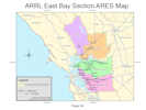
ARRL East Bay Section ARES Map | This map was requested by my local ARES coordinator to show the extent of the American Radio Relay League (ARRL) East Bay section of Amateur Radio Emergency Services (ARES). The data source is a combination of county divisions from Cal-Atlas (http://www.atlas.ca.gov/) and the ArcGIS Data & Maps 9.3 DVD. The map actually delivered can be seen at: http://www.schweich.com/images/CountySketch2.pdf
Location records that use this photograph:
Article records that use this photograph:
images/CountySketch2.jpg
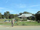
| Adelaida Cemetery
| 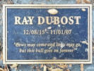
Grave marker in Adelaida Cemetery | Photographed 15 October 2017.
Location records that use this photograph:
Article records that use this photograph:
images/20171015_194450sm.jpg
| 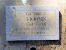
Grave marker in Adelaida Cemetery | Photographed 15 October 2017.
Location records that use this photograph:
Article records that use this photograph:
images/20171015_150530sm.jpg
| 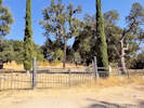
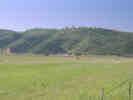
Adelaida Cemetery | Photographed 15 October 2017.
Location records that use this photograph:
Article records that use this photograph:
images/20171015_153323sm.jpg
| Alameda County
| 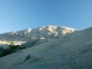
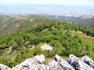
Mission Peak from the Switchbacks on the Horse Heaven Trail | Photograph taken 19-Nov-05.
Location records that use this photograph:
Article records that use this photograph:
images/IMGP2125sm.jpg
| 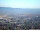
San Francisco Bay Area from Mission Peak | Photograph taken 19-Nov-05. The city of Fremont is directly below the mountain, and Coyote Hills are in the middle distance.
Location records that use this photograph:
Article records that use this photograph:
images/IMGP2156sm.jpg
| 
Mission Peak as seen from the west. | Photograph taken 23-Oct-2005.
Location records that use this photograph:
Article records that use this photograph:
images/IMGP2059asm.jpg
| 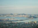
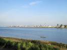
San Francisco Bay in the early morning. | Photograph taken in the early morning on 4-Dec-05.
Location records that use this photograph:
Article records that use this photograph:
images/IMGP2186sm.jpg
| Almaden
| 
Former mining offices at Almaden, California. |
Location records that use this photograph:
Article records that use this photograph:
images/0175_3301_2755_04.jpg
| 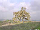
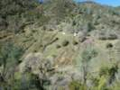
Oak tree in the hills at Almaden. | Cheryl waves "Hello."
Location records that use this photograph:
images/0175_3301_2755_07.jpg
| 
Looking north toward San Jose from Alamden, California. |
Location records that use this photograph:
Article records that use this photograph:
images/0175_3301_2755_06.jpg
| 
Former mine at Almaden, California. | The concrete structures were ore bins.
Location records that use this photograph:
images/0175_3301_2755_05.jpg
| Atascadero
| 
My dad's former house, 7905 San Marcos Road. | Photographed 14 October 2024.
Location records that use this photograph:
Article records that use this photograph:
images/20241014_115519sm.jpg
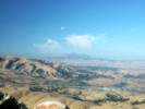
| 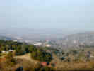
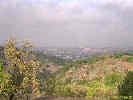
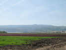
View of Atascadero on a hazy winter afternoon. | This view is looking east from a hill on the west side of Atascadero. The city hall of Atascadero is the domed structure in the center of the photograph. The Salinas River is behind the city hall and the hills to the right and left. Photograph taken in January 2002.
Location records that use this photograph:
Article records that use this photograph:
images/DSCN0280sm.jpg
| 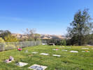
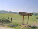
View from Atascadero Cemetery | Photographed 15 October 2017.
Location records that use this photograph:
Article records that use this photograph:
images/20171015_133202sm.jpg
| Avila Beach
| 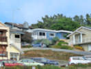
Houses above the beach. | Photographed 15 October 2024.
Location records that use this photograph:
Article records that use this photograph:
images/20241015_155228sm.jpg
| 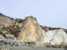
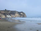
Faulted Miocene-age Opispo Formation on Avila Beach. | Photographed 15 October 2024. Undifferentiated tuffaceous, dolomitic siltstone and fine sandstone, rare diatomaceous siltstone, tuff, and resistant zeolitized tuff.
Location records that use this photograph:
Article records that use this photograph:
images/20241015_160421sm.jpg
| 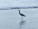
Snowy Egret on Avila Beach. | Photographed 15 October 2024. Smallish, yellow legs.
Location records that use this photograph:
Article records that use this photograph:
images/20241015_161100sm.jpg
| 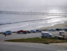
Avila Beach Pier with the Cal Poly Pier in the fog. | Photographed 15 October 2024.
Location records that use this photograph:
Article records that use this photograph:
images/20241015_163313sm.jpg
| 
On Avila Beach. | Photographed 15 October 2024.
Location records that use this photograph:
Article records that use this photograph:
images/20241015_155113sm.jpg
| Bakersfield
| 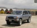
The 4Runner with 100,000 Miles. | Photograph taken 25 April 2005. As we were descending into Bakersfield on California Highway 58, the 4Runner turned over 100,000 miles at General Beale Road. We got off to buy some produce and to take this photo.
Article records that use this photograph:
images/IMGP1174sm.jpg
| Bay Farm Island
| 
View of the south shore of Alameda from Bay Farm Island | Photographed 14 January 2015.
Article records that use this photograph:
images/IMG40776sm.jpg
| 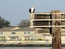
Osprey on San Leanadro Bay. | Photographed 14 January 2015.
Article records that use this photograph:
images/IMG40780sm.jpg
| Bear Valley Reservoir
| 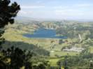
Bear Valley Reservoir, seen from Tilden Park. | Photograph taken 1 May 2005.
Location records that use this photograph:
Article records that use this photograph:
images/IMGP1177sm.jpg
| Big Sandy Creek
| 
End of County Maintain Road, locked gate ahead | Photographed 1 February 2013.
Article records that use this photograph:
images/IMG31023sm.jpg
| Bitterwater
| 
Junction of CA Hwy 25 and Coalinga Road near Bitterwater. | Coalinga Road provides access to Clear Creek and the New Idria area.
Article records that use this photograph:
images/1440-40.jpg
| 
Bitterwater, San Benito County, California. | There are many places named "Bitterwater," "Bitterwater Lake," or "Bitterwater Spring" in California. The DeLorme Atlas lists 8 places. Gudde's (1969) California Place Names notes that there are more than 50 Bitter Creeks and Lakes and Bitterwater Canyons in California. "Amargosa" is the Spanish adjective for "bitter."
Location records that use this photograph:
Article records that use this photograph:
images/1440-39.jpg
| Bradley
| 
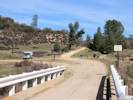
Bradley, California | Photographed 1 February 2013.
Location records that use this photograph:
Article records that use this photograph:
images/IMG_1016-7.jpg
| 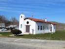
Our Lady of Guadalupe | Photographed 1 February 2013.
Location records that use this photograph:
Article records that use this photograph:
images/IMG_1018sm.jpg
| Buttonwillow
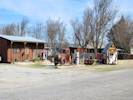
| 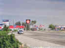
Businesses at Buttonwillow Junction | Nearly every gas station, fast food joint, and cheap motel chain is represented at Buttonwillow Junction. The actual town of Buttonwillow is 3 miles west on Highway 58. Photograph taken in May, 2001.
Article records that use this photograph:
images/0022_3291_4597_44.jpg
| 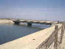
California Aqueduct. | California Highway 58 crosses the California Aqueduct near Buttonwillow. Photograph taken in May 2001.
Article records that use this photograph:
images/0022_3291_4597_47.jpg
| 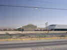
Cooperative Cotton Gin near Buttonwillow. | Cotton is a major crop in the southern San Joaquin Valley. This very large cotton gin is along side California Highway 58 near Buttonwillow. Photograph taken in May 2001.
Article records that use this photograph:
images/0022_3291_4597_45.jpg
| 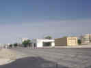
Highway 58 Through Buttonwillow | The agricultural businesses of Buttonwillow have grown up on both sides of California Highway 58.
Article records that use this photograph:
images/0022_3291_4597_46.jpg
| Carson Basin
| 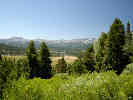
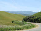
Hope Valley, looking southwest from CA Hwy 89. | Photograph taken July 31, 2004.
Location records that use this photograph:
Article records that use this photograph: images/IMGP0667sm.jpg
| 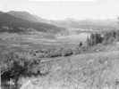
Hope Valley in Summer 1954 | Photograph taken sometime in Summer 1954.
Article records that use this photograph:
images/195407CarsonVy.jpg
| Cayucos
| 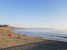
Cayucos Beach with Morro Rock in the Distance | Photographed 15 October 2017.
Location records that use this photograph:
Article records that use this photograph:
images/20171015_173837sm.jpg
| 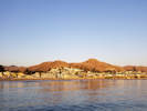
Cayucos in golden autumn light (aided by California wildfires). | Photographed 15 October 2017.
Location records that use this photograph:
Article records that use this photograph:
images/20171015_175736sm.jpg
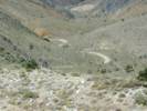
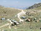
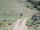
| Cerro Gordo
| 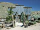
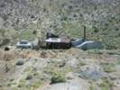
General Store in Cerro Gordo. | Photograph taken July 16, 2005.
Location records that use this photograph:
Article records that use this photograph:
images/IMGP1542sm.jpg
| 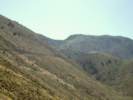
Looking toward Cerro Gordo from the vicinity of the Sunset Mine. | Photograph taken July 16, 2005.
Article records that use this photograph:
images/IMGP1541sm.jpg
| 
Last Mile of Cerro Gordo Road. | Photograph taken July 16, 2005.
Article records that use this photograph:
images/IMGP1549sm.jpg
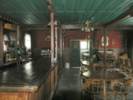
| 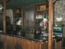
Inside the American Hotel | Photograph taken July 16, 2005.
Location records that use this photograph:
Article records that use this photograph:
images/IMGP1587sm.jpg
| 
The Cerro Gordo Road works it way up the hill. | Photograph taken July 16, 2005.
Article records that use this photograph:
images/IMGP1538sm.jpg
| 
Cerro Gordo from a ridge to the southwest. | Photograph taken July 16, 2005.
Location records that use this photograph:
Article records that use this photograph:
images/IMGP1553sm.jpg
| 
Steve wanted me to think we were going just a little way up this road. | � but I knew we were going to the top. Photograph taken July 16, 2005.
Article records that use this photograph:
images/IMGP1555sm.jpg
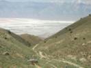
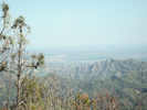
| 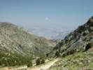
Looking into Saline Valley from Cerro Gordo | Photograph taken July 16, 2005.
Article records that use this photograph:
images/IMGP1544sm.jpg
| 
Hoist House, Cerro Gordo Mine. | Photograph taken July 16, 2005.
Location records that use this photograph:
Article records that use this photograph:
images/IMGP1547sm.jpg
| 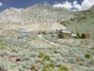
View of Cerro Gordo from the entrance to the town. | Photograph taken July 16, 2005.
Location records that use this photograph:
Article records that use this photograph:
images/IMGP1592sm.jpg
| 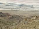
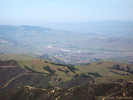
View of Owens Lake and Keeler from the Cerro Gordo Road. | Photograph taken July 16, 2005.
Location records that use this photograph:
Article records that use this photograph:
images/IMGP1535sm.jpg
| 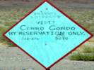
Sign at the bottom of the hill. | Photograph taken July 16, 2005.
Article records that use this photograph:
images/IMGP1608sm.jpg
| 
Looking up the Cerro Gordo Road. | Photograph taken July 16, 2005.
Article records that use this photograph:
images/IMGP1606sm.jpg
| 
Lower end of tramway at Cerro Gordo. | Photograph taken July 16, 2005.
Article records that use this photograph:
images/IMGP1603sm.jpg
| 
Steve has lunch on the porch of the American Hotel. | Photograph taken July 16, 2005.
Location records that use this photograph:
Article records that use this photograph:
images/IMGP1583sm.jpg
| 
Upper part of Cerro Gordo Road | Photograph taken July 16, 2005.
Location records that use this photograph:
Article records that use this photograph:
images/IMGP1602sm.jpg
| 
Inside the American Hotel | Photograph taken July 16, 2005.
Location records that use this photograph:
Article records that use this photograph:
images/IMGP1585sm.jpg
| 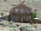
Front of the American Hotel. | Photograph taken July 16, 2005.
Location records that use this photograph:
Article records that use this photograph:
images/IMGP1589sm.jpg
| 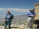
Two guys on top of the hill. | Photograph taken July 16, 2005.
Article records that use this photograph:
images/IMGP1579csm.jpg
| Coalinga
| 
Coalinga as seen from the southwest | Photograph taken March 22, 2008.
Article records that use this photograph:
images/IMG10482sm.jpg
| Consumnes River Preserve
| 
Visitor Center at Consumnes River Preserve | Photograph taken 8 November 2009.
Article records that use this photograph:
images/IMG02246sm.jpg
| 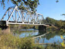
Union Pacific Railroad bridge over the Consumnes River. | Photograph taken 8 November 2009.
Location records that use this photograph:
Article records that use this photograph:
images/IMG02249sm.jpg
| 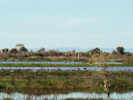
Three Sandhill Cranes at Consumnes River Preserve | Photograph taken 8 November 2009.
Article records that use this photograph:
images/IMG02247sm.jpg
| Contra Costa County
| 
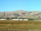
Mount Diablo as seen from Mission Peak. | Photograph taken 23-Oct-2005. The Sunol area, traversed by US Interstate 680 is in the foreground, and the Pleasanton - Dublin area is in the middleground.
Location records that use this photograph:
Article records that use this photograph:
images/IMGP2047sm.jpg
| 
Point Edith Salt Marsh | This is a CNPS field trip to see a small population of Cordylanthus mollis at Point Edith.
Article records that use this photograph:
images/TS7038-R1-14.jpg
| Copper Mountain
| 
Excerpt from the 12th Report of the State Mineralogist | Excerpt from: Crawford, J. J., 1894, Twelfth Report of the State Mineralogist. California State Mining Bureau. Goleta Mine (Quartz).�It is on the eastern base of the Sierra Nevada Mountains, 6 miles N.E. of Lundy. It is one of a series of mines on an immense ore deposit running N. and S. This has not yet been opened sufficiently to show its pitch; the eastern wall is limestone, the western a porphyry-like rock. On the eastern side of this deposit is a vein of copper ore (malachite), 6 to 20 ft. in width, and averaging 8 per cent of metallic copper. The copper carbonate impregnates an exceedingly crushed and decomposed rock. On the west is the gold and silver vein. This is much decomposed on the surface and in most of the workings, the quartz being honeycombed and in places almost replaced by the decomposed rock-mass and iron oxides. The quartz is evidently a replacement of the rock along the mineralized zone. The deposit is opened by two tunnels. The lower one is 1,190 ft. long and has not yet cut the ore body. The upper tunnel is 359 ft. above, and has a length of 360 ft. The copper vein has been drifted on N. 156 ft. and S. 182 ft. The upper tunnel runs through the quartz vein 67 ft. without striking the western wall. A drift has been run N. 40 ft. and S. 30 ft. From the south drift a winze has been sunk 56 ft. There are two cross-cuts on the vein from the north drift, 23 and 47 ft., without reaching the western wall. From the south drift two other cross-cuts have been run, respectively 38 and 49 ft. long. In places the decomposed ore is replaced by hard quartz, carrying iron sulphurets. The value of the ore is about equally distributed between gold and silver. On the same mine to the south and 400 ft. above, a shaft has been sunk 65 ft. on the vein. At this point the vein is 24 ft. wide. This is perhaps the largest ore deposit in the county, being traceable for over 7,000 ft. See our VIIIth Report, pp. 364 to 365. Goleta Mining Company, 330 Pine Street, San Francisco, owners. Montecito Mine (Quartz).�It lies 6 miles N.E. of Lundy, and joins the Goleta on the south. On this claim two tunnels have been run, 33 and 80 ft. long, respectively, cross-cutting the vein, but without reaching the western wall. A shaft has been sunk 40 ft. The character of the ore is the same as the Goleta. 1). E. Jones, of Lundy, Superintendent. Native Wonder and Mono Queen Claims (Quartz). �These properties were discovered the past year and have been only slightly developed. The Native Wonder is situated on the north side of a steep canon, west of Mono Lake, while the Mono Queen is opposite, on the south side of the cation. The Native Wonder runs nearly E. and W., and has been opened by a short drift showing a vein 18 in. in thickness. The Mono Queen is a blanket vein, and has been opened by a tunnel 70 ft. long. The ore is honeycombed, and is said to be high grade. E. C. Mattly, of Mono Lake, owner. Spartan Mine (Quartz).�This mine lies S. of that part of the Sterling Company's mine which was formerly known as the Detroit Copper Mine. Two tunnels have been run to cross-cut the vein. The upper is 120 ft. long, of which 90 ft. is in mineralized vein matter. The other tunnel, 180 ft. below, has at present a length of 245 ft., and is being run through limestone. The vein matter is partly a mineralized limestone and partly a porphyry. M. R. Burns, of Lundy, owner. Sterling (Detroit Copper). Mine (Quartz).�The property of the Sterling Company lies about 6 miles N.E. of Lundy. One claim lies north of the Goleta, and on the same ore body, and the other south of the Montecito. The claim on the north has been opened by a shaft 115 ft. deep. That on the south was formerly known as the Detroit Copper Mine, and was described in our VIIIth Report, pp. 364 to 365. In past years a large amount of work was done on this mine in an attempt to extract copper from an E. and W. vein. Sterling Mining Company, No.330 Pine Street, San Francisco, owners; D. E. Jones, of Lundy, Superintendent.
Location records that use this photograph:
Article records that use this photograph:
images/CrawfordJJ1894p177-184.jpg
| Cupertino
| 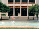
Rachel in front of the Flint Center | Photographed August 1986.
Article records that use this photograph:
images/img141cr.jpg
| Danby Lake
| 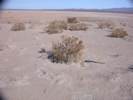
Vegetation on Danby Lake playa. | Photographed by Robert E. Reynolds, December 4, 2013.
Location records that use this photograph:
Article records that use this photograph:
images/DSCN4364sm.jpg
| 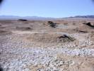
View mounds on Danby Lake playa. | Photographed by Robert E. Reynolds, December 4, 2013.
Location records that use this photograph:
Article records that use this photograph:
images/DSCN4355sm.jpg
| 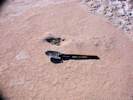
Sesuvium verrucosum on Danby Lake playa. | Photographed by Robert E. Reynolds, December 4, 2013.
Location records that use this photograph:
Article records that use this photograph:
images/DSCN4360sm.jpg
| 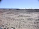
View of Danby Lake playa. | Photographed by Robert E. Reynolds, December 4, 2013.
Location records that use this photograph:
Article records that use this photograph:
images/DSCN4341sm.jpg
| Eel River
| 
Eel River between Dyerville and McCann | Photograph taken August 3, 2003.
Location records that use this photograph:
images/DSCN1035sm.jpg
| Fremont Peak
| 
End of the road at Fremont Peak. | Photograph taken 28-Apr-07. There are two campgrounds. Valley View Campground is just down the road to the left, and Oak Point Campground is on the knoll in the center of the photo. The main picnic area is between the parking lot and the Oak Point Campground.The Fremont Peak Observatory is out of the photo to the right.
Location records that use this photograph:
Article records that use this photograph:
images/IMG_1377sm.jpg
| 
Fremont Peak Observatory from the Peak | Photograph taken 28-Apr-07. The Fremont Peak Observatory Association is at http://www.fpoa.net/.
Location records that use this photograph:
Article records that use this photograph:
images/IMG_1379sm.jpg
| 
Fremont Peak seen from San Juan Grade Road | Photograph taken 28-Apr-07.
Location records that use this photograph:
Article records that use this photograph:
images/IMG_1388sm.jpg
| 
San Juan Bautista as seen from Fremont Peak. | Photograph taken 28-Apr-07. San Juan Bautista and the San Juan Valley are in the middleground. The view is just west of north.
Location records that use this photograph:
images/IMG_1381sm.jpg
| 
Interpretive sign at Fremont Peak. | Photograph taken 28-Apr-07. This interpretive sign is at the upper parking lot, near the trailhead for the peak trail.
Location records that use this photograph:
Article records that use this photograph:
images/IMG_1384sm.jpg
| 
Fremont Peak from San Juan Valley | Photograph taken 28-Apr-07 from the San Juan Highway north of San Juan Bautista.
Location records that use this photograph:
Article records that use this photograph:
images/IMG_1376sm.jpg
| 
Fremont Peak from the Salinas Valley near Natividad | Photograph taken 28-Apr-07 from Old Stage Road, just south of Natividad.
Location records that use this photograph:
Article records that use this photograph:
images/IMG_1389sm.jpg
| Fresno County
| 
Looking northeast in downtown Coalinga | Photograph taken 4-Feb-06.
Location records that use this photograph:
Article records that use this photograph:
images/IMGP2267sm.jpg
| 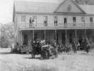
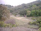
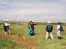
Group photo at Fresno Hot Springs | Courtesy of Ed Kreyenhagen.
Location records that use this photograph:
Article records that use this photograph:
images/Kreyenhagen2.jpg
| 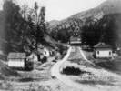
General view of (then) Fresno Hot Springs | Courtesy of Ed Kreyenhagen.
Location records that use this photograph:
Article records that use this photograph:
images/Kreyenhagen1.jpg
| 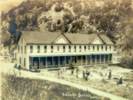
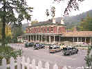
Photograph of hotel at Fresno Hot Springs | Courtesy of Ed Kreyenhagen.
Location records that use this photograph:
Article records that use this photograph:
images/Kreyenhagen3.jpg
| 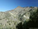
Kreyenhagen Peak from Coalinga Mineral Springs | Photograph taken 5-Feb-06.
Location records that use this photograph:
Article records that use this photograph:
images/IMGP2291sm.jpg
| 
Springs at Coalinga Mineral Springs | Photograph taken 5-Feb-06.
Location records that use this photograph:
Article records that use this photograph:
images/IMGP2289sm.jpg
| | ||||||||||||||||||||||||||