Eastern Mojave Vegetation
Tom Schweich
|
Eastern Mojave Vegetation
| California Highway 203 - Eastern Sierra |
|
Tom Schweich |

|
(No Preface) | |
|
Other articles:
|
Junction: Old Highway 395 | |
| This little section of road that extends California Highway 203 to the old Highway is called Substation Road. | ||
|
Literature Cited:
Other articles:
|
Junction:
| |
|
Other articles:
Locations:
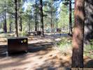
Shady Rest Campground.
|
Shady Rest Campground Very highly groomed; the pine needles have been raked away exposing the volcanic sand underneath. I think I would prefer to camp on the pine needles. | |
|
Other articles:
|
Junction: Old Mammoth Road | |
|
|
Mammoth LakesThe local newspaper is the Mammoth Times, which has lots of links to other web sites. The Mammoth Community Water district operates a GPS Community Base Station that may be helpful if you are performing research in that area. | |
|
Literature Cited:
|
Valentine Eastern Sierra ReserveFlora prepared by Howald (2000) | |
|
Other articles:
|
Lake Mary RoadTake the Lake Mary Road to see the area where trees have been killed by Carbon Dioxide gasses at Horseshoe Lake. For more information see Gases and Tree Kill on Mammoth Mountain in Long Valley caldera, California. | |
|
Other articles:
|
Mammoth Lakes Scenic LoopJunction: Forest Road 3S23 "Mammoth Scenic Loop", otherwise known as the "Mammoth Lakes Volcanic Escape Route," but I'm sure the Chamber of Commerce would object to this name. | |
|
Literature Cited:
|
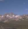
Mammoth MountainsGood place to ski, if you're into that. | |
|
Literature Cited:
Locations: Minaret Summit. |
Minaret Summit
The ancestral San Joaquin River headed at least as far east as the present Mono Lake basin, possibly farther north or east in Nevada, and its course across the west slope of the Sierra Nevada has changed little since the Eocene. The San Joaquin River was beheaded at the present Sierran divide, specifically Minaret Summit and volcanics to the east, about 3.2 m.y. ago by a combination of volcanic activity and relative down-faulting to the east (Huber, 1981) Howald (1989) points out that rain shadow effect is ameliorated in the Mammoth Mountain area because it lies directly east of the Mammoth Pass to Minaret Summit gap [to the San Joaquin River valley], a lower section of the crest where storms pass to the east more quickly, bringing greater amounts of rain and especially snow. Indeed, the ancestral San Joaquin River may have passed this way draining an area at the head of the Walker Basin (and thus the larger Lahontan system), and the Owens RiverDeath Valley system (and thus, potentially, the Colorado River) westward perhaps to the Pacific Ocean (Phillips, F. M., 2008). It thus holds a unique position as a potential switching yard for aquatic species transfers (Reheis et al., 2002). | |
| Agnew Meadows Campground | ||
|
Literature Cited:
Locations: Starkweather Lake. |
Starkweather Lake | |
| Soda Springs Campground | ||
|
Other articles:
|
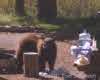
Pumice Flat CampgroundThe Pumice Flat campground is along the San Joaquin river. Nice place for lunch. This bear had Bisquick and Wesson Oil for lunch. | |
|
|
Devils Postpile National MonumentThe Park Services' web site at http://www.nps.gov/depo/ is very brief. | |
 Devil's Postpile. Devil's Postpile.
|
Here is my picture of the Postpile. Took this one in late morning, on a Fall day. The lighting would be better in mid afternoon for photography. | |
 Devil's Postpile. Devil's Postpile.
|
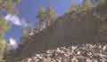
The top of the Postpile looks like this, the columns have been polished by glaciers. | |
|
Other articles:
|
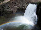
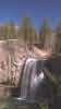
Rainbow Falls TrailheadThe trailhead to Rainbow Falls is at the end of California Highway 203. The walk to view Rainbow Falls is downhill, a little more than a mile. Once at the viewpoint, you can walk down a staircase to the bottom of the falls. | |
| If you have a question or a comment you may write to me at: tomas@schweich.com I sometimes post interesting questions in my FAQ, but I never disclose your full name or address. |
Date and time this article was prepared: 5/12/2025 2:42:38 PM |