Eastern Mojave Vegetation
Edited by Tom Schweich
|
Eastern Mojave Vegetation
| United States Highway 16A |
|
Edited by Tom Schweich |

|
U.S. Highway 16A (US 16A) is a 36.971-mile-long (59.499 km) scenic United States Numbered Highway. It is an alternate route for US 16. It splits from US 16 in the Black Hills of the southwestern part of the U.S. state of South Dakota. The highway's western terminus is an intersection with US 16, US 385, and South Dakota Highway 89 (SD 89) in Custer. The eastern terminus is at an interchange with US 16 called Keystone Wye south of Rapid City. Portions of US 16A are known as the Iron Mountain Road, named after the peak it summits. | ||||||||
|
Other articles:
|
Junction: US 16, US 385, SD 89 south | ||||||||
|
Junction: SD 89, north. | |||||||||
|
Junction: SD 87, south | |||||||||
|
Other articles:
|
Junction: SD 87, north. | ||||||||
|
Other articles:
|
Junction: Custer State Park 1 “Wildlife Loop” | ||||||||
|
Junction: SD 36, east | |||||||||
|
Other articles:
Locations:
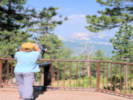
Norbeck Memorial Overlook.
|
Norbeck Overlook
| ||||||||
|
Junction: S. Playhouse Rd.
Other articles:
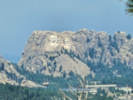
Junction: SD 244, west to Mount Rushmore.
Junction: SD 40, east.
Junction: US Highway 16, “Keystone Wye.”
Date and time this article was prepared:
5/12/2025 2:58:56 PM
|