Eastern Mojave Vegetation
Edited by Tom Schweich
|
Eastern Mojave Vegetation
| South Dakota Highway 87 |
|
Edited by Tom Schweich |

|
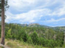
South Dakota Highway 87 (SD 87) is a 37.894-mile-long (60.984 km) state highway in the southwestern part of the U.S. state of South Dakota. It travels through the Black Hills region. The highway's southern terminus is at an intersection with U.S. Route 385 (US 385), about 6 miles (9.7 km) southeast of Pringle, within the southwestern part of Wind Cave National Park. Its northern terminus is at an intersection with US 16/US 385 about 3 miles (4.8 km) south-southwest of Hill City, within the east-central part of the Black Hills National Forest.
The highway travels through Wind Cave National Park. The northern 14 miles (23 km) of the highway is also known as the Needles Highway. The Needles Highway, along with the concurrency with US 16A, are also part of the Peter Norbeck Scenic Byway. Portions of the highway are also a section of Custer State Park's Wildlife Loop. |
|||
|
Other articles:
|
Junction: US Hwy 16, US Hwy 385 | |||
|
Junction: SD Hwy 89, to Custer. | ||||
|
Other articles:
Locations:
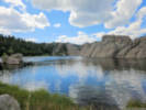
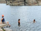
Sylvan Lake.
|
Sylvan Lake
| |||
|
Other articles:
|
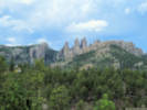
Needles Scenic View | |||
|
Junction: S. Playhouse Road, to US Hwy 16A | ||||
|
Other articles:
|
Junction: US Hwy 16A, east | |||
|
Junction: US Hwy 16A, west | ||||
|
Other articles:
|
Junction: Custer State Park 1 “Wildlife Loop” | |||
|
Junction: US Highway 385 | ||||
| If you have a question or a comment you may write to me at: tomas@schweich.com I sometimes post interesting questions in my FAQ, but I never disclose your full name or address. |
Date and time this article was prepared: 5/12/2025 2:58:31 PM |