 Eastern Mojave Vegetation
Tom Schweich
 Eastern Mojave Vegetation
| California Highway 127 |
|
Tom Schweich |

|
CA Hwy 127 is the southern gateway to Death Valley. | ||
|
Other articles:
|
Nevada above … California below … Junction: Nevada Highway 373, north to US Highway 95 in Amargosa Valley. | ||
|
Other articles:
Locations:
Death Valley Junction.
|
Death Valley JunctionJunction: California Highway 190, west to Death Valley. | ||
|
Other articles:
|
Junction: Ash Meadows Road | ||
|
Other articles:
|
Every time I drive by this canyon at the very southeastern tip of the Funeral Mountains, I wonder whether it might be a landslide. Of course, I'll also have to confess that I've not been sufficiently curious that I went to any effort to go look at it. | ||
|
Other articles:
|
Funeral mountains to the north. | ||
|
Literature Cited:
|
To the east is the Eagle Mountain Salina, not a name recognized by the GNIS. This salina has been prospected for lithium brines and claimed by Pacific Imperial Mines, Inc. (Pacific Imperial Mines, Inc., 2011). There is some concern that mining on this salina, specifically pumping of subsurface brines might affect the water table in Ash Meadows and further imperil the pupfish. | ||
|
Locations:
Eagle Mountain.
|
Eagle Mountain | ||
|
Other articles:
|
Junction: California Highway 178, west over Salsberry Pass and Jubilee Pass to southern Death Valley. | ||
|
Locations:
Shoshone.
|
Moonrise over Shoshone, at the Shoshone Motel | ||
|
Locations:
Shoshone.
|
On this warm May evening, there were nighthawks flying over the lights of the motel parking lot. | ||
|
Locations:
Shoshone.
|
Shoshone | ||
|
Other articles:
|
Junction: California Highway 178, access to “Castles of Clay,” east to Pahrump Nevada. | ||
|
Other articles:
|
Junction: Furnace Creek Wash Road, northwest to Greenwater Valley. | ||
|
Other articles:
|
Junction: Furnace Creek Road, southeast to Tecopa. | ||
| Highway 127 skirts Tecopa Valley. To the east you can see the town of Tecopa. You can read about the geology of Tecopa Valley in Geophysical constraints on the cessation of extension and thickness of basin fill in Tecopa Valley, California. | |||
 Borax Spring at Zabriskie. Borax Spring at Zabriskie.
|
|||
|
Other articles:
|
Junction: Old Spanish Trail Road | ||
|
Locations: Ibex Hills. Ibex Pass. Sperry Hills. |
Ibex PassSperry Hills on the east; Ibex Hills on the west. | ||
|
Literature Cited:
Locations: Dumont Dunes. |
Junction: Dumont Dunes Road | ||
|
Locations:
Amargosa River.
|
|||
|
Locations:
Amargosa River.
Amargosa River.
|
Amargosa River | ||
|
Other articles:
|
Junction: Harry Wade Road, west turning north into Death Valley. | ||
|
Locations:
Dumont Dunes.
|
|||
|
Locations: Avawatz Mountains. |
Avawatz Mountains to the southwest. | ||
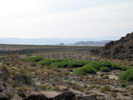 Salt Creek, looking downstream toward the Amargosa River Salt Creek, looking downstream toward the Amargosa River
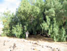 Large Athel tree at Salt Creek Large Athel tree at Salt Creek
|
|||
|
Locations:
Salt Creek.
Salt Spring Hills.
|
Salt CreekWater flow generated by several small desert springs, as well as winter drainage from neighboring Silurian Valley, come together at Salt Spring Hills to form a unique tributary to the Amargosa River known as Salt Creek. In an otherwise very harsh environment, this water provides the gift of life to a huge variety of desert wildlife like bighorn sheep to drink, but also food and shelter necessary for animals such as Gambels Quail to survive and raise young. The march, mesquite trees and succulent vegetative scrub this water supports, provide countless homes for animals like the ring-tail, bobcat, badger and over 150 bird species. The riparian habitat, or streamside vegetation, present at Salt Creek is virtually the only water based habitat in over fifteen square miles of desert. Ensuring continued water flow and the health of the native plant communities found here are essential to sustaining numerous wildlife species. Extensive efforts are being made by the Bureau of Land Management, California Dept. of Fish and Game, and numerous partners such as Quail Unlimited and the Los Angeles Conservation Corps, to remove exotic weeds, restore native plants and maintain this scarce water resource. | ||
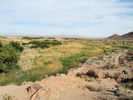 Salt Creek, looking upstream, to the southeast. Salt Creek, looking upstream, to the southeast.
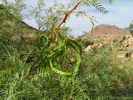 Honey Mesquite at Salt Creek Honey Mesquite at Salt Creek
|
|||
|
Literature Cited:
Other articles:
|
In one of the early studies on desert varnish, Engel and Sharp (1958) performed wet chemical analyses on varnish, the underlying weathered rind, and fresh rock from ten locations in southeast California. One of the locations was near Salt Spring (sic), on a steep bedrock slope facing east about 300 yards west of the highway in the NW 1/4 of Sec. 32, T. 18 N., R. 7 E., at elevation 630 feet (Avawatz Pass quadrangle). Engel and Sharp found that (1) varnish on stones seated in soil or colluvium is derived largely from that material, (2) varnish on large bedrock esposures come from weathered parts of the rock, (3) air-borne material is probably a minor contributor. | ||
|
Other articles:
Locations: Renoville. |
Renoville | ||
|
Locations: Silurian Valley. |
|||
|
Other articles:
|
|||
|
Locations: Silurian Lake. |
Silurian Lake | ||
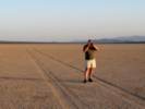 Photography on Silurian Lake in the late Afternoon Photography on Silurian Lake in the late Afternoon
|
|||
|
Other articles:
|
| ||
|
Literature Cited:
Locations: Silver Lake. |
Silver Lake SpillwayLake Mojave, the name given to a large lake filling the present day Soda and Silver Lakes, overflowed at hills on the north side of Silver Lake, cascading down a narrow channel and thence to Death Valley. Full Lake Mojave and associated overflow to Death Valley occurred between 19 and 17 ka, and episodically from 14 to 9 ka. Since that time, there has been no fluvial communication between the Mojave River and points lower than Silver Lake, but episodic flow of the Mojave River from the San Bernardino Mountains to Silver Lake occurs regularly, including Winter 2005 (Miller, 2005). | ||
 Upper spillway, looking upstream. Upper spillway, looking upstream.
 Upper spillway, looking upstream. Upper spillway, looking upstream.
 Upper spillway, looking downstream. Upper spillway, looking downstream.
|
|||
|
Other articles:
|
Junction: Powerline Road | ||
|
Literature Cited:
Other articles:
Locations: Silver Lake (site). |
Silver Lake (site)
Junction: Halloran Springs Road, east through the Halloran Hills to Halloran Springs at US Interstate 15. | ||
|
Locations:
Silver Lake.
|
|||
|
Locations: Silver Lake. |
Silver Lake | ||
 Avawatz Mountains from CA Highway 127. Avawatz Mountains from CA Highway 127.
|
View of the Avawatz Mountains to the northwest across Silver Lake. | ||
|
Other articles:
Locations: Baker. |
BakerJunctions:
| ||
| If you have a question or a comment you may write to me at: tomas@schweich.com I sometimes post interesting questions in my FAQ, but I never disclose your full name or address. |
Date and time this article was prepared: 3/23/2025 5:54:18 PM |