Eastern Mojave Vegetation
Tom Schweich
|
Eastern Mojave Vegetation
| US Highway 24 |
|
Tom Schweich |

|
West to east from Colorado to Michigan | |||
|
Other articles:
|
Junction: US Interstate 70, just below Vail, turn east for Vail, or west for Glenwood Springs and Grand Junction. | |||
|
Other articles:
Locations:
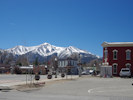
Minturn.
|
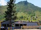
Minturn
| |||
|
Literature Cited:
Other articles:
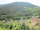
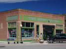
Locations: Gilman. |
Gilman
| |||
|
Other articles:
Locations:
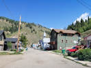
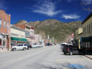
Red Cliff.
|
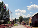
Red Cliff
| |||
|
Other articles:
|
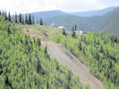
Junction: Forest Road 703, southwest up Homestake Creek to Homestake Reservoir. | |||
|
Other articles:
|
Junction: Forest Road 705 “No Name Road,” leads eventually to Wurtz Ditch and back to US Highway 24. | |||
Pando | ||||
|
Other articles:
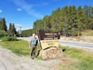
Locations:
Camp Hale.
|
Camp HaleCamp Hale, between Red Cliff and Leadville in the Eagle River valley in Colorado, was a U.S. Army training facility constructed in 1942 for what became the 10th Mountain Division. It was named for General Irving Hale and was at an elevation of 9,200 feet (2,800 m) above sea level. Onslow S. Rolfe, who had developed mountain warfare techniques as commander of the 87th Mountain Infantry Regiment, was selected to command Camp Hale. Soldiers were trained in mountain climbing, Alpine and Nordic skiing, cold-weather survival as well as various weapons and ordnance. When it was in full operation, approximately 15,000 soldiers were housed there. | |||
|
Other articles:
Locations: Burton Ditch. |
Junction: Forest Road 101 “Tennesee Pass Road”, to Cooper Hill Ski Area, and Ewing (Burton) Ditch. | |||
|
Other articles:
Locations:
Tennessee Pass.
|
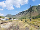
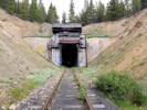
Tennessee PassThe Denver and Rio Grande Western Railroad constructed a narrow gauge railroad over Tennessee Pass in 1881 as part of their extension to the Aspen area in order to beat the Colorado Midland's standard gauge route to the rich mining area. In 1890, a new standard gauge line was built from Pueblo, to Grand Junction, and jointly with the Colorado Midland Railway, a tunnel was constructed about 200 ft (61 m) below the summit. In 1945, the old Tennessee Pass Tunnel was replaced by a newer tunnel. In recent times, the Rio Grande's Tennessee Pass line was the highest active mainline railroad mountain pass in the United States. The line, now owned by the Union Pacific Railroad, is currently embargoed (the tracks are out of service but still in place). | |||
|
Other articles:
|
Junction: County Road 21, northeast to the Tennessee Pass Tunnel. | |||
|
Other articles:
Locations:
Crane Park.
|
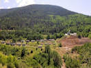
Crane Park | |||
|
Other articles:
|
Junction: Forest Road 100 “Meadow Drive,” a.k.a. County Road 19, generally west in the direction of Wurtz (Wurts) Ditch. | |||
|
Locations: West Tennessee Creek. |
Cross West Tennessee Creek. | |||
|
Other articles:
Locations:
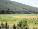
Tennessee Park.
|
Tennessee ParkAs near as I can tell, nothing of note occurred in Tennessee Park.
| |||
|
Other articles:
|
Junction: County Road 18 “East Tennessee Road” | |||
|
Other articles:
|
Junction: Forest Road 109 | |||
|
Other articles:
|
Junction: Colorado Highway 91 Colorado Highway 91 ascends Fremont Pass along the East Fork Arkansas River to the Climax Molybdenum Mine and then descends Tenmile Creek to Wheeler Junction, now most commonly known as the Copper Mountain Ski Area. | |||
| County Road 17, Mountain View Drive. | ||||
| 15th Street | ||||
| 14th Street. | ||||
| 13th Street. | ||||
| 12th Street. | ||||
| 11th Street. | ||||
| 10th Street. | ||||
| Poplar Street, Highway 24 follows north northwest. | ||||
| East 9th Street, Highway 24 follows east north east. | ||||
|
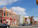
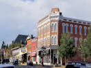
Locations: Leadville. |
LeadvilleLeadville City Hall, on Harrison street, between 8th Street and 9th Street. | |||
| 8th Street | ||||
|
Other articles:
|
7th Street, becomes County Route 3. | |||
|
Other articles:
|
6th Street, traffic signal | |||
|
Other articles:
|
Intersection: 5th Street, to the east becomes County Route 1. | |||
|
Other articles:
|
4th Street | |||
|
Other articles:
|
Leadville Historic District | |||
| 3rd Street | ||||
| 2nd Street | ||||
|
Other articles:
|
Monroe Street, access to County Route 2. | |||
| Highway curves southeast. | ||||
|
Other articles:
|
Junction: County Road 4 “McWethy Drive”, to Turquoise Lake. | |||
|
Other articles:
|
Junction: Colorado State Highway 300, west to the Leadville National Fish Hatchery. | |||
|
Other articles:
|
Junction: Lake County Road 7 “Weston Pass Road”, south, then east over Weston Pass. | |||
|
Other articles:
|
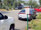
Interpretive panel at narrows along the Arkansas River. | |||
|
Other articles:
|
Junction: Colorado State Highway 82, west to Independence Pass, then Aspen, and Glenwood Springs. | |||
|
Lake County above … Chaffee County below … | ||||
|
Locations: Granite. |
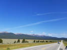
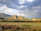
GraniteSituated between the Mosquito and the Sawatch mountain ranges, Granite is a high mountain town located on the Arkansas River midway between Leadville to the north, and Buena Vista to the south. It is in close proximity to the second and third highest peaks in the contiguous United States, Mount Elbert and Mount Massive. The town has a rich history from its days during the Pike's Peak Gold Rush, when it began as a mining camp and quickly boomed into a city of 3,000, holding the county seat. Early prospectors, such as Horace Tabor, were attracted to the area. | |||
|
Other articles:
|
Otero Pumping PlantEast of the highway is the Otero Pumping Plant. It takes water from the Arkansas River and pumps it over Trout Creek Pass. Half the water is delivered to Spinney Mountain Reservoir for use by the City of Aurora. The remaining half continues in the pipeline to Ramparts Reservoir for the City of Colorado Springs. | |||
|
Other articles:
Locations:
Elephant Rock.
|
||||
|
Other articles:
Locations:
Buena Vista.
|
Buena Vista
| |||
|
Other articles:
Locations: Cottonwood Creek. |
Cross Cottonwood Creek | |||
|
Other articles:
|
Junction: US Highway 285, south. | |||
|
|
Trout Creek Pass | |||
|
Other articles:
|
Junction: US Highway 285, north. | |||
|
Other articles:
|
Junction: Colorado Highway 9, north. | |||
|
Other articles:
|
Junction: Colorado Highway 9, south. | |||
|
Locations: South Park. |
“South Park”The flat commonly known as “South Park,” although the Board of Geographic Names does not accept that name for this flat. | |||
|
Other articles:
|
Junction: Park County Road 77 “Tarryall Road,”, along Tarryall Creek to US Highway 285 at Jefferson. A good road and pretty drive, if you are not in a hurry. | |||
|
|
Lake George | |||
|
Other articles:
Locations: Florissant. |
FlorissantJunction: Teller County Road 1, south to Florissant Fossil Beds National Monument. | |||
|
Locations: Ute Pass. |
Ute PassNamed for an ancient Ute Indian route which extended from South Park through Manitou Springs to the plains. | |||
|
|
Divide | |||
|
Other articles:
|
Colorado SpringsJunction: US Interstate 25 | |||
|
Colorado above … Kansas below … | ||||
|
Kansas above … Missouri below … | ||||
|
Missouri above … Illinois below … | ||||
|
Illinois above … Indiana below … | ||||
|
Indiana above … Ohio below … | ||||
|
Ohio above … Michigan below … | ||||
| Junction: US Interstate 75, near Clarkston, MI, east end of highway. | ||||
| If you have a question or a comment you may write to me at: tomas@schweich.com I sometimes post interesting questions in my FAQ, but I never disclose your full name or address. |
Date and time this article was prepared: 3/23/2025 6:09:05 PM |