Eastern Mojave Vegetation
Tom Schweich
|
Eastern Mojave Vegetation
| California Highway 89 |
|
Tom Schweich |

|
California Highway 89 winds its way through northeastern California from US Interstate 5 at Mount Shasta, through Lassen National Park, and past Lake Tahoe before ending at U. S. Highway 395 on the West Walker River near the Nevada border. | |||||||||||||||||||||||||||||||
|
Other articles:
Locations: Mount Shasta (town). |
Mt. ShastaJunction: US I-5 | |||||||||||||||||||||||||||||||
|
Locations: McCloud. |
McCloud | |||||||||||||||||||||||||||||||
| Junction: CA Hwy 299 | ||||||||||||||||||||||||||||||||
|
Locations: Hat Creek. |
Hat Creek | |||||||||||||||||||||||||||||||
|
Other articles:
Locations:
Subway Cave Lava Tubes.
|
Junction: Lassen National Forest
| |||||||||||||||||||||||||||||||
|
Other articles:
|
Junction: California Highway 44, east toward Susanville. Also access to Butte Lake and Cinder Cone in the north part of Lassen Volcanic National Park. | |||||||||||||||||||||||||||||||
|
Locations: Old Station. |
Old Station | |||||||||||||||||||||||||||||||
|
Locations: Big Spring. |
Big Spring | |||||||||||||||||||||||||||||||
|
Lassen National Park Below. | ||||||||||||||||||||||||||||||||
|
Other articles:
|
Junction: California Highway 44, west to Redding. | |||||||||||||||||||||||||||||||
|
|
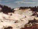
Hot Rock | |||||||||||||||||||||||||||||||
|
Other articles:
Locations:
Chaos Crags.
Lassen National Park.
|
Emigrant Pass
| |||||||||||||||||||||||||||||||
|
|
Summit Lake | |||||||||||||||||||||||||||||||
|
Other articles:
Locations:
Bumpass Hell.
|
| |||||||||||||||||||||||||||||||
|
|
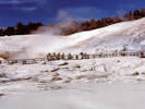
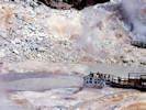
Sulphur Works | |||||||||||||||||||||||||||||||
|
Lassen National Park above. | ||||||||||||||||||||||||||||||||
|
Other articles:
|
Junction: California Highway 36, west to US Interstate 5 at Red Bluff. | |||||||||||||||||||||||||||||||
| Junction: CA Hwy 32 | ||||||||||||||||||||||||||||||||
|
Other articles:
|
Junction: California Highway 36, east to Susanvile. | |||||||||||||||||||||||||||||||
| Junction: CA Hwy 147 | ||||||||||||||||||||||||||||||||
|
|
Greenville | |||||||||||||||||||||||||||||||
|
|
Crescent Mills | |||||||||||||||||||||||||||||||
| Junction: California Highway 207, Plumas County A22 | ||||||||||||||||||||||||||||||||
|
|
Indian Mills | |||||||||||||||||||||||||||||||
|
Other articles:
|
Junction: CA Hwy 70 W | |||||||||||||||||||||||||||||||
|
|
Keddie | |||||||||||||||||||||||||||||||
|
|
Butterfly Valley | |||||||||||||||||||||||||||||||
|
Locations: Quincy. |
Quincy | |||||||||||||||||||||||||||||||
|
Other articles:
|
Junction: CA Hwy 70 East | |||||||||||||||||||||||||||||||
|
Locations:
Graeagle.
|
Graeagle | |||||||||||||||||||||||||||||||
| Junction: Plumas County Road A 15 | ||||||||||||||||||||||||||||||||
|
Sierra County, California Nevada County, California | ||||||||||||||||||||||||||||||||
|
|
Calpine | |||||||||||||||||||||||||||||||
|
Other articles:
|
Junction: California Highway 49 South | |||||||||||||||||||||||||||||||
|
Other articles:
Locations: Sierraville. |
SierravilleJunction California Highway 49 North | |||||||||||||||||||||||||||||||
|
Plumas County, California Sierra County, California | ||||||||||||||||||||||||||||||||
|
Other articles:
|
Junction: US I-80 East | |||||||||||||||||||||||||||||||
|
Other articles:
|
Junction: US Interstate 80, west, over Donner Summit, to Sacramento and San Francisco. | |||||||||||||||||||||||||||||||
|
Nevada County, California Placer County, California | ||||||||||||||||||||||||||||||||
|
Locations: Squaw Valley. |
Squaw ValleySki area. | |||||||||||||||||||||||||||||||
|
Literature Cited:
|
Tahoe City Lumber Company At this location, Stop 12, Tahoe City, in Schweickert et al. (2000), can be viewed evidence of early lakes in the basin and the formation of lava dams. | |||||||||||||||||||||||||||||||
|
Other articles:
Locations: Tahoe City. |
Tahoe CityJunction: California Highway 28, north and east around the north shore of Lake Tahoe.California Highway 89 continues south along the west shore of Lake Tahoe. | |||||||||||||||||||||||||||||||
| Kaspian exit, Blackwood Canyon Road, exit here for trail to top of Eagle Rock. | ||||||||||||||||||||||||||||||||
|
Locations: Idlewild. |
IdlewildSmall town on west shore of Lake Tahoe, called out here for the adjacent Eagle Rock. | |||||||||||||||||||||||||||||||
|
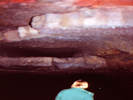
Literature Cited:
Locations: Eagle Rock. |
Eagle RockEagle Rock at the mouth of Blackwood Canyon is made of volcanic breccia with angular to rounded fragments of scoriaceous black latite or basalt, and sparse andesite. It is Stop 11 in Schweickert, et al. (2000), p. 18).Use trail from Blackwood Canyon Road to climb Eagle Rock. | |||||||||||||||||||||||||||||||
|
Locations: Tahoe Pines. |
Tahoe PinesSmall town on the northern end of McKinney Bay of Lake Tahoe. | |||||||||||||||||||||||||||||||
|
Literature Cited:
Locations: McKinney Bay. |
McKinney BayBay on the western side of Lake Tahoe. Thought to be underlain by a very large landslide that created a huge tsunami in Lake Tahoe (Schweickert, et al., 2000). | |||||||||||||||||||||||||||||||
|
Locations: Homewood. |
HomewoodSki area. | |||||||||||||||||||||||||||||||
|
Placer County, California El Dorado County, California | ||||||||||||||||||||||||||||||||
|
Literature Cited:
Locations: Sugar Pine Point. |
Sugar Pine PointSugar Pine Point is thought to be a erosional feature from a tsunami on Lake Tahoe (Schweickert, et al., 2000, p. 17). | |||||||||||||||||||||||||||||||
|
Literature Cited:
|
Ehrman Mansion Picnic Area. This is Stop 10, Sugar Pine Point in Schweickert, et al. (2000), p. 16. Evidence for a large tsunami generated by a megalandslide at McKinney Bay is found here. | |||||||||||||||||||||||||||||||
|
Locations: Meeks Bay. |
Meeks Bay | |||||||||||||||||||||||||||||||
|
Literature Cited:
|
Lateral moraine forms the south limb of Meeks Bay. Follow subdivision roads onto the crest of the Tahoe-age right lateral moraine. Park at the end of the road. This is Stop 9, Meeks Bay right lateral moraines in Schweickert, et al. (2000), p. 16. | |||||||||||||||||||||||||||||||
|
Literature Cited:
|
The parking area just north of Eagle Creek is Stop 8, Emerald Bay -- Vikingsholm viewpoint in Schweickert, et al (2000), p. 15. | |||||||||||||||||||||||||||||||
|
Literature Cited:
Locations: Emerald Bay. |
Emerald BayEmerald Bay occupies a glacial valley and an end moraine forms the mouth of the bay (Schweickert, et al., 2000, p. 15). | |||||||||||||||||||||||||||||||
|
|
Emerald Bay State ParkEmerald Bay occupies a glacial valley and an end moraine forms the mouth of the bay. | |||||||||||||||||||||||||||||||
|
Other articles:
|
Junction: US Highway 50, east to Stateline, Nevada, to Carson City, and across Nevada to Utah. | |||||||||||||||||||||||||||||||
|
Other articles:
|
Junction: US Highway 50, west over Echo Summit to Sacramento, California. | |||||||||||||||||||||||||||||||
|
Locations: Luther Pass. |
Luther Pass | |||||||||||||||||||||||||||||||
|
Other articles:
Locations:
Hope Valley.
|
| |||||||||||||||||||||||||||||||
|
Other articles:
|
Junction: California Highway 88, west over Carson Pass through Jackson, California, to Stockton, California. | |||||||||||||||||||||||||||||||
| Sorenson's | ||||||||||||||||||||||||||||||||
|
Other articles:
|
Junction: California Highway 88, east into the Carson Valley and US Highway 395 near Minden, Nevada. | |||||||||||||||||||||||||||||||
|
Locations: Markleeville. |
Markleeville | |||||||||||||||||||||||||||||||
|
Other articles:
|
Mt. BullionJunction: California Highway 4, west over Ebbets Pass to Angels Camp, California, and then to Stockton, California.
|
Other articles:
Junction: Loope Canyon Road
|
|
| Loope
|
Locations: Heenan Lake.
Heenan Lake
|
|
Locations: Sagehen Flat.
Sagehen Flat
|
|
Other articles:
Junction: Leviathan Mine Road, generally north past the Leviathan Mine then turning east in Nevada to join US Highway 395 at Double Spring Flat.
|
|
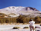
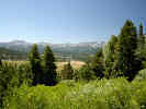
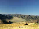
 Sagehen Flat and Heenan Lake, looking south. Sagehen Flat and Heenan Lake, looking south.
|
|
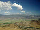
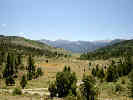
 Silver Peak from Monitor Pass. Silver Peak from Monitor Pass.
|
|
Other articles:
Locations:
Monitor Pass.
|
|
Other articles:
Junction: F. R. 31083, "Big Spring Loop", north several miles along the west flank of Leviathan Peak, before turning east through the Poison Creek and Mountaineer Creek drainages, finally returning to CA Hwy 89 east of Leviathan Peak.
|
|
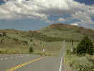
Locations: Monitor Pass.
| Monitor Pass
|
Other articles:
Junction: F. R. 31083, "Big Spring Loop", to Big Spring and the headwaters of Mountaineer Creek.
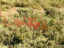
| This paintbrush (Castilleja linariifolia) was collected in the little vallry just north of here.
|
Other articles:
Locations:
Sweetwater Mountains.
|
|
Literature Cited:
Other articles:
From the Nevada Appeal, 10 February 2016:
| Completion of 17 1/2 miles of new highway which connects by a more direct route the county seats of Bridgeport in Mono County and Markleeville in Alpine County will be celebrated by the boards of supervisors of the two counties with a dedication ceremony Sunday, when the new road will be opened formally to traffic.
|
Other articles:
Junction: U. S. Highway 395
|
If you have a question or a comment you may write to me at:
tas4@schweich.com
I sometimes post interesting questions in my FAQ, but I never disclose your full name or address.
|
|
Date and time this article was prepared: 5/10/2024 10:58:16 AM |