|
Wyoming Highway 28 (WYO 28) is a 96.5-mile (155.3 km) long Wyoming state highway known as the South Pass Highway. It travels from its split from Wyoming Highway 372 near the Seedskadee National Wildlife Refuge, across the high plains and over South Pass until its junction with U.S. Route 287 8 miles (13 km) south of Lander.
|
|
Other articles:
• US Highway 287:
at WY 28;
|
Junction: US Highway 287, north to Lander, or southeast to Rawlins.
|
|
Other articles:
• Field Notes:
4 Sept 2018;
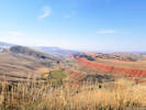
 Red Canyon Rim south of Lander. Red Canyon Rim south of Lander.
|
Red Canyon Rim
|
|
Locations:
Atlantic City Iron Mine.
|
Atlantic City Iron Mine
|
|
Other articles:
• Field Notes:
4 Sept 2018;
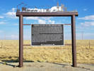
 Lander Cut-Off on the Oregon Trail Lander Cut-Off on the Oregon Trail
|
Crossing of the Lander Cut-off
Lander Cut-Off on the Oregon Trail
| |
In 1858, this ancient path, which had been used by Indians,
explorers and mountain men as a shortcut to the Snake River
country was developed by Frederick Lander into an alternate
route on the Oregon Trail.
What is commonly called the Lander Trail or Lander Cut-off
starts 9 miles to the southeast at Burnt Ranch (directly
behind this sign), crosses the Sweetwater River 6 miles to
the northwest, and continues along Lander Creek for 13 miles
to the Continental Divide at Little Sandy Creek, the
headwaters of the Pacific Ocean. From there it travels west
across the Green River Valley, the Wyoming Range, and the
Salt River Range before entering present-day Idaho.
The Cut-Off rejoins the original Oregon Trail near Fort Hall.
| |
This wagon road was favored by travelers for many reasons.
The cut-off saved as much as 7 days travel compared to the
old route through Fort Bridger, avoided the expensive
ferries across the Green River to the south, and bypassed
the 50-mile waterless desert of the Sublette Cut-Off.
Its longest waterless section was only 10 miles, and it had
access to abundant grass and firewood. The Lander Cut-Off
was used by an estimated 13,000 emigrants its first year,
with 9,000 of them signing a statement of support for the
road at Fort Hall. While use dwindled after the completion
of the trans-continental railroad in 1869, the trail was
still used by emigrants into the 20th century and played a
role in the settlement of the Upper Green River Valley.
| |
Sublete County Museum Board
|
|
|
Other articles:
• Oregon Buttes Road:
at WY 28;
|
Junction: Oregon Buttes Road, Lander Cutoff Road
Turn south here for the Summit of the Original South Pass on the Emigrant Trail.
|
|
Other articles:
• Field Notes:
4 Sept 2018;
Locations:
South Pass.
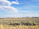
 South Pass. South Pass.
|
South Pass

View south toward Oregon Buttes. |
|
|
Other articles:
• US Highway 191:
at Farson;
|
Farson
Junction: US Highway 191
|
|
|
Junction: Wyoming Highway 372
|
|
If you have a question or a comment you may write to me at:
tomas@schweich.com
I sometimes post interesting questions in my FAQ, but I never disclose your full name or address.
|
[Home Page] [Site Map]
Date and time this article was prepared:
5/12/2025 3:00:57 PM
|
 Eastern Mojave Vegetation
 Eastern Mojave Vegetation
