Eastern Mojave Vegetation
Tom Schweich
|
Eastern Mojave Vegetation
| US Highway 26 |
|
Tom Schweich |

|
U.S. Route 26 is an east-west United States highway. It started in Ogallala, Nebraska, and gradually grew to reach the West Coast in Oregon. When the U.S. highway system was first defined, it was limited to Nebraska and Wyoming; by the 1950s, it continued into Idaho and Oregon. The highway's eastern terminus is in Ogallala, Nebraska at an intersection with Interstate 80. Its western terminus is south of Seaside, Oregon at an intersection with U.S. Route 101. Prior to 2004, the route's last 20 miles (32 km) were co-signed with U.S. Route 101 from the highways' junction south of Seaside north to Astoria where its intersection with U.S. Route 30 was also U.S. 30's western terminus. | |||||||||
|
Other articles:
|
Junction: US Highway 101 | |||||||||
|
Other articles:
|
PortlandJunction: US Interstate 405 | |||||||||
|
Other articles:
|
Junction: US Interstate 405, south. | |||||||||
| Pass under US Interstate 5. | ||||||||||
| Cross Willamette River on Ross Island Bridge. | ||||||||||
|
Other articles:
|
||||||||||
|
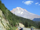
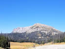
Locations: Government Camp. |
Government CampHigh point of US Hwy 26 near Mt. Hood. | |||||||||
|
Other articles:
|
Junction: Oregon Highway 126, west to Redmond, Eugene, and ending at US Highway 101 at Florence Oregon. | |||||||||
|
|
Prineville | |||||||||
|
Other articles:
|
Junction: Oregon Highway 380, "SE Paulina Highway." SE Combs Flat Road | |||||||||
|
Other articles:
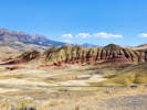
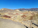
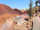
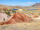
Locations:
Painted Hills.
|
Junction: Burnt Ranch Road, to Painted Hills.
| |||||||||
|
Other articles:
|
Junction: Oregon Highway 19: to Thomas Condon Paleontological Center. | |||||||||
|
Junction: County Road 21, to Cedar Grove Botanical Area. The Cedar Grove Botanical Area covers about 26 acres and contains the only isolated stand of Alaska yellow cedar (Callitropsis nootkatensis (D. Don) Oerst. ex D.P. Little) east of the Cascades in the United States. This grove, is located on the northeast slope of Aldrich Mountain at the head of Buck Cabin Creek. | ||||||||||
|
Other articles:
Locations: Mount Vernon. |
Junction: US Highway 395, north to Pendleton. | |||||||||
|
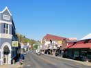
Other articles:
Locations: John Day. |
John DayJunction: US Highway 395, south to Burns. | |||||||||
|
Other articles:
|
Intersection: Dayton Street | |||||||||
|
Other articles:
|
||||||||||
|
Oregon above
Idaho below | ||||||||||
|
Other articles:
|
Junction: US Interstate 84, at its Exit 26. The routes of US Highways 20 and 26 follow I-84 for three miles, then exit east into Boise. | |||||||||
|
Other articles:
|
Junction: US Interstate 84, at its Exit 29 “Franklin Road.” The routes of US Highways 20 and 26 go east roughly upstream along the Boise River, before going through downtown Boise. | |||||||||
|
Other articles:
|
Junction: US Interstate 84 | |||||||||
|
Other articles:
|
BlissJunction: US Interstate 84 at its Exit 140. | |||||||||
|
Other articles:
|
ShoshoneJunction: US Highway 93, north to Challis. | |||||||||
|
Other articles:
|
Junction: US Highway 20, west across the Camas Prairie. US Highway 26 is concurrent with US Highway 20 from this point east through Arco to near Atomic City. See US Highway 20 for commentary. | |||||||||
|
|
Carey | |||||||||
|
|
Arco | |||||||||
|
Other articles:
|
US Highway 26 is concurrent with US Highway 20 from here west to Carey. See US Highway 20 for commentary. Junction: US Highway 20, east, directly to Idaho Falls. | |||||||||
|
Other articles:
|
Junction: US Interstate 15 US Highway 26 runs concurrent with US Interstate 15 from this junction near the town near Blackfoot northeast to the US I-15 Exit 116 which is at the south edge of Idaho Falls. | |||||||||
|
Other articles:
|
US Highway 26 runs concurrent with US I 15 from this exit, near Idaho Falls, southwest to Exit 93, near Blackfoot, Idaho. Junction: US Interstate 15 | |||||||||
|
Locations: Idaho Falls. |
Idaho Falls | |||||||||
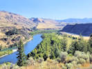
|
Other articles:
Locations:
Snake River.
|
Clark Hill Rest Area | |||||||||
|
Idaho above
Wyoming below .. | ||||||||||
|
Other articles:
|
Alpine JunctionJunction: US Highway 89, south through Montpelier to Logan. | |||||||||
|
Other articles:
|
Hoback JunctionJunction: US Highway 189, US Highway 191 US Highway 189 goes south through Kemmerer to US I-80 pretty much nowhere. US Highway 191 goes south through Rock Springs on US I-80 to Vernal and Price. | |||||||||
|
Locations: Jackson. |
Jackson | |||||||||
|
Other articles:
|
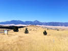
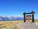
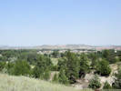
Grand Teton National Park Scenic ViewGrand Teton National Park below | |||||||||
|
Other articles:
|
Junction: Teton Park Road | |||||||||
|
Other articles:
Locations:
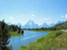
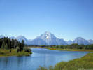
Oxbow Bend.
|
Oxbow Bend
| |||||||||
|
Other articles:
|
Moran JunctionJunction: US Highway 89, US Highway 191, north through Yellowstone National Park. At Moran Junction, US Highways 89, 191, and 287 go north through Yellowstone National Park. US Highways 26, 89, and 191 go south through Jackson and along the Snake River. US Highways 26 and 287 go southeast through the Wind River Range. | |||||||||
|
Grand Teton National Park above
| ||||||||||
|
Other articles:
Locations:
Togwotee Pass.
|
Togwotee Pass
| |||||||||
|
Other articles:
|
Junction: US Highway 287, south to Lander, and then US I-80 at Rawlins. | |||||||||
|
Other articles:
|
RivertonJunction: Wyoming Highway 789, southwest to Lander, or jointly with US Hwy 26 northeast to Shoshoni. | |||||||||
|
Other articles:
|
ShoshoniJunction: US Highway 20, north to Thermopolis, or east to Caspar. | |||||||||
|
Other articles:
|
Junction: US Interstate 25, at its Exit 189. US Highway 26 diverges from I-25 slightly along the North Platte River past Glenrock, then permanently at Dwyer Junction to Guernsey. | |||||||||
|
Other articles:
|
Dwyer JunctionJunction: US Interstate 25 at its Exit 92. | |||||||||
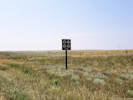
|
Other articles:
|
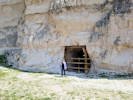
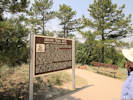
One of many signs that show places that a historic trail crosses a modern road. | |||||||||
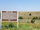
|
Other articles:
|
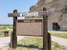
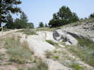
Rifle Pit HillThis location is indicated on the USGS 7.5" quadrangle names Guernsey Reservoir as “Oregon Trail Marker.” | |||||||||
|
Locations: North Platte River. |
Cross North Platte River. | |||||||||
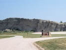
|
Other articles:
Locations:
Guernsey.
Oregon Trail.
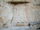
Register Cliff.
|
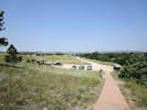
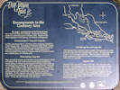
GuernseyThe Oregon Trail Ruts and Register Cliff are just south of town.
| |||||||||
|
|
Fort Laramie | |||||||||
|
Wyoming above
Nebraska below | ||||||||||
| Junction: US Interstate 80. | ||||||||||
| If you have a question or a comment you may write to me at: tas4@schweich.com I sometimes post interesting questions in my FAQ, but I never disclose your full name or address. |
Date and time this article was prepared: 5/10/2024 11:10:34 AM |