Eastern Mojave Vegetation
|
Eastern Mojave Vegetation
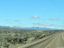
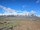
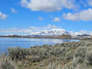
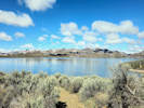
| Independence Mountains, Elko County, Nevada. |
|
Gazetteer Query: G.N.I.S.
|
||
|
The Independence Mountains are a mountain range in northern Elko County, Nevada, United States.
They are called Settoya in Shoshoni.
The range reaches a maximum elevation of 10,439 ft (3,182 m) on the summit of McAfee Peak.
The range extends northward approximately 70 mi (110 km) from a point near Carlin to the banks of the Owyhee River.
To the east is the North Fork of the Humboldt River, and to the west is the Owyhee Desert.
Passing to the south is the main branch of the Humboldt River, and near the northern end of the range is the Wild Horse State Recreation Area.
The Owyhee River is a tributary to the Snake-Columbia system, while the Humboldt is within the Great Basin.
Articles that refer to this location:
| ||
| No collections made at this location. | ||
| If you have a question or a comment you may write to me at: tomas@schweich.com I sometimes post interesting questions in my FAQ, but I never disclose your full name or address. |
A, B, C,
D, E, F,
G, H, I,
J, K, L,
M, Date and time this article was prepared:7:39:09 PM, 12/9/2024. | |